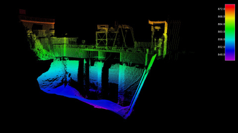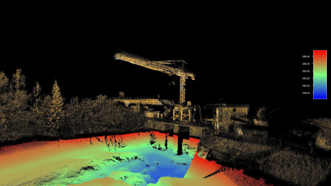


The Seabed lidar system, equipped with a Puck sensor, provides complete above water point cloud data and can operate in harsh maritime conditions. The system conducts 3D data capture of intricate measurements of inshore, nearshore and inland waterways from up to 100 meters away. It is designed to be simple to mobilize and easy to use without the need for specialized training or qualifications, delivering rapid results that can save time and money.
The Seabed lidar system can be combined with a bathymetric multi-beam echo-sounder to provide a complete 3D, georeferenced image above and below water. The data can be used to rapidly inspect structural integrity of bridges, dams and piers, and be a resource for preservation and sustainability planning. Regular inspections of bridges and waterways are also important to improve navigation safety, especially in high traffic areas where the depth is shallow.
“We selected Velodyne’s Puck because it produces the high quality, consistent data our customers need,” said Elice Collewijn, General Manager, Seabed, which is based in Amsterdam, The Netherlands. “The Puck has demonstrated outstanding reliability and power efficiency while operating in severe offshore situations. The sensor allows us to capture vital, high-resolution data to accurately measure and analyze marine environments.”
“Seabed is helping companies transform their businesses with offshore 3D mapping solutions which can deliver highly accurate, detailed data collection to support safe navigation and protection of marine environments,” said Erich Smidt, Executive Director Europe, Velodyne Lidar. “Their solutions demonstrate how Velodyne’s sensors provide the performance, range and compact form factor needed for versatile mobile mapping systems that can enable a sustainable future.”
Velodyne Puck compact, versatile sensors deliver a high-resolution image to measure and analyze a variety of environments. They provide high quality resolution and performance along with a full 360-degree environmental view to deliver real-time 3D data. The Puck has best-in-class power efficiency, which advances the travel range and sustainability of applications.
About Velodyne Lidar
Velodyne Lidar (Nasdaq: VLDR, VLDRW) ushered in a new era of autonomous technology with the invention of real-time surround view lidar sensors. Velodyne, the global leader in lidar, is known for its broad portfolio of breakthrough lidar technologies. Velodyne’s revolutionary sensor and software solutions provide flexibility, quality and performance to meet the needs of a wide range of industries, including autonomous vehicles, advanced driver assistance systems (ADAS), robotics, unmanned aerial vehicles (UAV), smart cities and security. Through continuous innovation, Velodyne strives to transform lives and communities by advancing safer mobility for all. For more information, visit www.velodynelidar.com.
Forward Looking Statements
This press release contains "forward looking statements" within the meaning of the "safe harbor" provisions of the United States Private Securities Litigation Reform Act of 1995 including, without limitation, all statements other than historical fact and include, without limitation, statements regarding Velodyne’s target markets, new products, development efforts, competition. When used in this press release, the words "estimates," "projected," "expects," "anticipates," "forecasts," "plans," "intends," "believes," "seeks," "may," "will," “can,” "should," "future," "propose" and variations of these words or similar expressions (or the negative versions of such words or expressions) are intended to identify forward-looking statements. These forward-looking statements are not guarantees of future performance, conditions or results and involve a number of known and unknown risks, uncertainties, assumptions and other important factors, many of which are outside Velodyne's control, that could cause actual results or outcomes to differ materially from those discussed in the forward-looking statements. Important factors, among others, that may affect actual results or outcomes include the uncertain impact of the COVID-19 pandemic on Velodyne's and its customers' businesses; Velodyne's ability to manage growth; Velodyne's ability to execute its business plan; uncertainties related to the ability of Velodyne's customers to commercialize their products and the ultimate market acceptance of these products; uncertainties regarding government regulation and adoption of lidar; the rate and degree of market acceptance of Velodyne's products; the success of other competing lidar and sensor-related products and services that exist or may become available; uncertainties related to Velodyne's current litigation and potential litigation involving Velodyne or the validity or enforceability of Velodyne's intellectual property; and general economic and market conditions impacting demand for Velodyne's products and services. Velodyne undertakes no obligation to update or revise any forward-looking statements, whether as a result of new information, future events or otherwise, except as required by law.